
Top Crossing
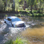
The beautiful King River in North-Eastern Victoria was the setting for this trip.The track in to the campground isn’t seasonally closed so theoretically you can go there pretty-well any time. However the track fords the river twice – I’ve driven it a number of times and each time the river depth has been 600-700mm at most, but after rain you could be looking at faster and deeper water so beware! And you must know your safe fording depth. Nevertheless it’s a lovely campground with a single drop toilet, nestled beside a stretch of the river with a couple of nice pools to cool down in on a hot summer’s day.
On day 2 we headed back to Sandy Flat, fording the King again 3 times, then climbed up to the Wabonga Plateau with some really nice ridgeline views and good 4WDing, generally pretty easy though there’s one giant bog – most of us threaded the needle between the 2 deep holes without any issues but a couple of mud-lovers took the harder way…
This is a nice weekend trip, comfortably do-able from Melbourne or southern NSW with plenty of time to relax by the river.
- Distance
- 598.04 km
- Elevation gain
- +4,564 m
- Elevation loss
- −4,565 m
- Max elevation
- 1,218 m
- Waypoints
- 10
View my trip video on Relive here:
You can also download a GPX file here:
Download Top Crossing GPX file